I'd been wanting to check out the streamlined Palouse hills near Hammer Grade Road (Cheney-Palouse Scabland Tract) and had also been interested in visiting a viewpoint along the Little Goose Dam Road (South of river). Dam crossings are not allowed on weekends so ... I ended up driving to the gate on the north end of Little Goose Dam and then backtracking to Washtucna Coulee, then south and around to Starbuck. Not a problem, I like it out there.
Before I get to the trip photos, let me add one taken last Thursday. Teresa and I made a trip to Ellensburg to attend the Ellensburg IAFI meeting [Speaker: Richard Waitt USGS]. I wish I could make it up to more of their meetings. Nick and Karl do a great job.
On the way, we made a quick stop south of Sentinel Gap to view huge field of boulders that settled out as floodwater entered the Pasco Basin.
[Click any image to enlarge]

Teresa and erratic boulder near Mattawa, WA. Sentinel Gap in the distance.

Pretty good variety Sunday. Lots of streamlined Palouse hills, gravel bars and a quiet hike to the bottom of the Palouse River Canyon.

Early morning along Hammer Grade Road. This area was once covered with rolling loess hills up to 250 feet thick. In major channels the Ice Age Floods removed huge amounts of loess (windblown silt), exposing the basalt bedrock. Many loess islands were left behind (like the one pictured above).
"Here are streamlined, prow-pointed and steeply scarped loessial islands 150 feet high" J Harlen Bretz

Wheat is grown for miles to the left of image. A ten mile wide flood tract exists to the right. [View South]
1. Hammer Grade Road.
2. Wheat field.
3. Scarped Palouse hill.
4. Streamline Palouse hill.

Same thing here. Flood-swept basalt and streamlined hills to west. Wheat country on the right.
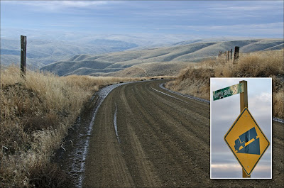
Hammer Grade is no problem when bare. Might want to think twice before attempting to descend through snow and ice.

Flood-swept scabland and scarped Palouse hills. If you want to search for the missing soil ... Try looking in the Willamette Valley and Pacific Ocean.
Two photos below from Bruce Bjornstad
I sure like these shots. I'm impressed the farmer has maximized his wheat acreage by farming a loess island!


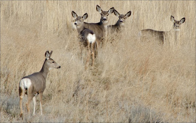

Once you get to the bottom of Hammer Grade (near the Snake River), start looking for depositional features left by the Ice Age Floods.

Exposed flood deposits near Little Goose Dam (Snake River). Note band of fine material that settled out during slackwater conditions. I'll add a few photos below that show similar slackwater band(s) exposed downstream at Lake Sacajawea Bar. Road in distance climbs to top of Little Goose Dam. Recreation area marked with "1".
Call 1-888-DAMINFO (1-888-326-4636) for Dam Crossing Info.

Red arrow marks exposed flood deposits shown in previous image.


Steve recently sent me a few Snake River photos that led me to the Little Goose Dam Road overlook. I like the soft lighting in this one along with the cool fence!
Thanks again Steve and I hope we can get out for a hike next spring!

Map shows lower Hammer Grade Road, Old Vantage Bridge (Moved from Vantage area when Wanapum Dam built) and Starbuck, WA. The Old Vantage Bridge crosses the Snake River just below Palouse and Snake confluence.


Little Goose Dam at top left. Interesting flood deposits are found along SR-261 near Starbuck. Steve's overlook is marked with camera symbol.

1. Huge flood bar. I'm trying to find a name for it.
2. Mid-Canyon Bar (J Harlen Bretz described this feature in 1928).
3. Mouth of Palouse River Canyon (right).
Bruce Bjornstad describes the Mid-Canyon Bar in his book On the Trail of the Ice Age Floods.
"Floodwaters rushing down the Palouse River cataract canyon plowed into the high walls of the Snake River valley, forcing the water to split and rush in opposite directions. Some floodwaters surged up the Snake River for 80 miles, all the way to Lewiston, Idaho, and beyond. The rest of the floodwater went down the Snake River, eventually emptying into the Pasco Basin."


The Mid-Canyon Bar is 2.5 miles long. A tremendous amount of gravel has been removed from bar below the mid-Canyon Bar (note the giant current ripples that are about to disappear).

Little Goose Dam Airport was built on a Snake River bar. The water behind Little Goose Dam (Lake Bryan - Max. pool 646.5 feet) covers much of the bar.
YouTube video uploaded by fazonsazar on Sep 8, 2007. Video shows Cessna 172 landing at Little Goose Dam and Lock on a windy afternoon in late August.

Please scroll back up about six images (Google Earth) and check out the Tucannon drainage. Huge volumes of sediment laden floodwater surged into this valley during Ice Age Flood events.
Ya gotta feel sorry for the beavers living on this stretch of river 15,000 years ago. Feeling safe living off the main Snake channel ... Then suddenly forced to ride out a 700 foot deep flood surge that came from a downstream direction!

Tucannon Valley - View west from Little Goose Dam Road (on the way to the overlook). FYI- There isn't an official "Overlook". Just pull over when Snake River is in view.

At least six rhythmites are visible at the Starbuck exposure. Approximatly 25 have been found in the Tucannon Valley.
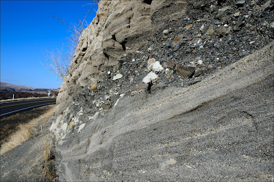
Bruce Bjornstad explains that the coarse basaltic gravel between some of the beds may be material shed off the steep valley walls between floods.

Use caution if you visit this area on foot. Motorists are dealing with curves and elevation changes ... probably not expecting pedestrians.
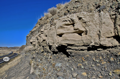
The last time I visited this location, a woman stopped to ask "Are you OK?". I don't think she had much of an appreciation for the flood feature I'd driven many miles to examine.
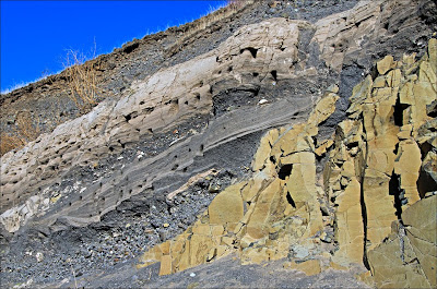
Ice Age Flood rhythmites and Columbia River Basalt. I'm standing too close!!! Good thing Skye Cooley thought enough to back up and capture a panoramic view of this exposure. See below.

Thanks to Skye for letting me use this amazing shot of Starbuck rhythmites draped over Columbia River Basalt. (Click to enlarge)
Check out some great shots at Skye's: Picasa Clastic Dikes Gallery.

Now I'm on the south side of the Snake River - Looking at the first flood deposits shown above. The exposure between Hammer Grade and Little Goose Dam. You can see the slackwater band.

Here's a shot of a similar slackwater band exposed downstream on the 400' tall Lake Sacajawea Bar.

A few images here from a visit to the Lake Sacajawea Bar earlier this year. The size of many Snake River gravel bars is impressive. Hard to image what happened along the Snake River between Pasco and Lewiston at the end of the last Ice Age. Usually the floodwaters raced down the Snake and into the Pasco Basin. Other times when Wallula Gap restricted the flow, floodwater rushed up the Snake River. During several intervals, the flow stabalized and fine material was allowed to settle out to form the slackwater bands we see today.


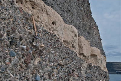
Bruce Bjornstad has placed an interesting Geocache near this location.

"The gravel pit excavated by the railroad here has a scarp 200 feet high. The gravel is unindurated and slides easily, so that the structure is difficult to decipher. But it is 99 per cent basalt." - J Harlen Bretz 1925

The streamlined hill shapes are often referred to as teardrop, ship-like or airfoil-like. Earlier this year I attended an Ellensburg IAFI chapter meeting and heard Vic Baker compare them to "A trout in a stream". I like that one.
Several excellent examples of streamlined Palouse Hills are visible from the intersection of SR-261 and the entrance road to Palouse Falls State Park.
"These hills consist of "islands" of loess that appear to float in a sea of basalt scabland. Their teardrop shape consists of a prominant steep prow on the upstream end and long tapered tails on the downstream end. This shape, which was repeated over and over again in the formation of streamlined sedimentary hills, is not a coincidence. During Ice Age flooding, the hills were streamlined so their length was usually about three times longer than their width; this hydrodynamic shape provided the least amount of drag to the floodwaters that formed them. - Bjornstad"

NASA has some impressive shots of streamlined hills on Mars. Scientist estimate flood volumes on Mars were 10 times the largest Missoula flood.
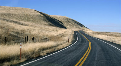
SR-261 near the entrance to Palouse Falls State Park - The scarped Palouse hills aren't too far off the highway.

Teresa and I were in Washington, DC the week of Thanksgiving - I noticed this Palouse River Canyon USGS photo in the Smithsonian National Museum of Natural History.

Nice day. Too much driving and not enough hiking but still fun!
Glacial Lake Missoula floodwaters were responsible for most of the features pictured above; However, another large flood swept through this stretch of the Snake River about 17,400 years ago. Click video above to watch Nick Zentner interview USGS Geologist Jim O'Connor. Jim talks about the Lake Bonneville Flood at the 14 minute mark of interview.
Watch Nick interview other guests from the US Geological Survey and various regional organizations at Central Rocks.
"Central Rocks" aims to promote an appreciation and understanding of Washington geology - while also shedding light on research and teaching of CWU faculty.


7 comments:
Loved your photos.
Loved the photos! Enjoyed the information too. Well said. Thank you
Drove through this area over last weekend - awesome place, isn't it?
Thank you for posting such excellent photos.
Excellent article
Glad this site is still up. I travel HWY 261 2x a year, usually.
Thanks,
Upriverdavid
All the pic are so representative of your story, it is perfect.
But why in the brown-pale layer of the soil, there are many hole.
I think it is hole of worm that can eat human
Damn I poisoned A 90's sci-fi movie name Tremor.
Btw, I want to visit this blog again.
Thank you
Post a Comment