Though not one of my favorite hikes, there are several interesting Ice Age Flood features along the John Wayne Trail south of Vantage, WA.
The U.S. Army controls land on both sides of the trail and DOES NOT allow off trail use. Saturday's hike was 7.4 miles out with a return trip retracing the same stretch of railbed.
This section of trail did rate as a Seattle P.I. Hike of the week: John Wayne Trail
The trail description on the Wikipedia site includes mention of the Ice Age Floods:
"However the trail provides access to the unique geological erosion features of the Channeled Scablands regions of Washington state, and several stretches have been recognized as providing access to this area created by the cataclysmic Missoula Floods that swept periodically across eastern Washington and down the Columbia River Plateau during the Pleistocene epoch."
Open Wikipedia Trail Description page.

Just a short walk from the trailhead to one of the many erratic boulders found along the trail. These large pieces of granite were rafted into the area in icebergs during Ice Age Flood events. Visit nearby Ginkgo State Park to learn more about this area known to geologists as the "Iceberg Graveyard".
Here's a clip from a story about plans to relocate antelope to the area:
The most pronghorn-friendly area is from Vantage to the Army’s sprawling Yakima Training Center in part because of its shrub steppe vegetation, Martorello said.
“It’s the best contiguous piece of habitat, and with the rolling hills, it’s perfect for them,” he said.

When traveling SR243, you may have noticed a large gravel bar a few hundred yards south of Wanapum Dam. This view shows bar from west end. Photo doesn't do it justice - Maybe clicking to enlarge image will help?

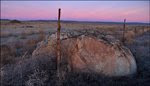
This big fella has been shoved around by the Army. The flood sculpted mesa in the distance is an interesting feature.

Flood tumbled rocks from distant places are scattered over the area.

Another gravel bar image that might be more impressive if you click to enlarge. A large portion of this one appears to have been removed during construction of the railroad.

This erratic was uncovered during the excavation of the bar shown above.

This erratic has slid downslope and ended up on the old railbed. The grade doesn't seem steep when walking but the 18 mile 2.2% grade was a tough pull for locomotives. The first link below opens a story about "Helper Engines" that were added to trains making the climb to the summit at Boylston. The second link opens a video that might be interesting to those familiar with the area. Some of the scenes are 1953 footage of this stretch of the Milwaukee Road.

An amazing Ice Age Floods feature along the trail is this erratic cluster at 1,248' elevation. Impressive to see these rocks stranded 700' above and several miles from the Columbia River.

I noticed this USGS benchmark on the other side of the trail when standing near the cluster pictured above. Arrow points to granite stone used to support post.


 Large erratic uncovered in railroad cut.
I stopped several times when small colorful rocks caught my eye.
 Eagle Scout Neil Cantral organized the development and installation of several interpretive displays along the trail. The panel shown describes Native Americans that have used this stretch of the Columbia River for thousands of years. Other panels tell the story of early miners and pioneers. My personal favorite is one placed near the abandoned town of Doris titled "Basalt Flows and Catastrophic Floods".
After the John Wayne Trail hike, I had time for a couple more short trips in the Vantage area. Later in the day I ended up in Frenchman Coulee looking across the Columbia River wondering ... Just how big is that erratic over there? Maybe I'll find out next Saturday.
Erratic pictured sits in the Whiskey Dick unit of the L.T. Murray Wildlife Area.
More information about the John Wayne Trail from the Washington State Park's page:
John Wayne Pioneer Trail
The John Wayne Pioneer Trail follows the former roadbed of the Chicago-Milwaukee-St. Paul-Pacific Railroad two-thirds of the way across Washington, from the western slopes of the Cascade Mountains to the border with Idaho. The 100-mile portion from Cedar Falls (near North Bend) to the Columbia River near Vantage is managed as Iron Horse State Park. It is open to hikers, bikers, equestrians and horse-drawn wagons in summer, and to snowmobiles, dog sleds and cross-country skiers in winter.
Blue bubble marks trailhead. John Wayne Trail shown with RR track symbol (passes though the RR town of Doris that no longer exists).