
I finally made it down to see the famous "She Who Watches" (Tsagaglalal) in the Columbia Gorge. Indians that lived in this area for hundreds perhaps thousands of years scratched and painted scenes into and on the basalt cliffs that were shaped by the Columbia River and Ice Age Floods.
Wikipedia Page: Tsagaglalal
The legend of Tsagaglalal

I'm slower than most when driving from Pasco to The Dalles (Too much to see). I lose time in the Wallula Gap area and all the way down the Gorge. The stretch of scabland above John Day Dam (N. side) is facinating. Saturday morning Mt. Hood views were nice along the Washington side. This shot was taken near Columbia Hills State Park.

Columbia Hills State Park includes Horsethief Lake, Horsethief Butte and Dalles Mountain Ranch.
The State Parks Dept. describes history of park:
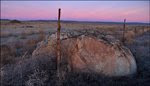
The basalt rock resulted from a series of lava flows which emerged from cracks in the earth's crust and blanketed the entire eastern Washington/Oregon region.
The Butte and the surrounding Columbia River channel were carved out of basalt rock by floods following the last ice age.
For centuries, the park was the site of a Native American village. The Lewis and Clark expedition camped at the village and described its wooden houses in one of their journals. The village was flooded by the waters of The Dalles Dam.
Oral history states that the park received its former name -- Horsethief Lake State Park -- from workers in the U.S. Army Corps of Engineers who developed the site. The workers thought the terrain was similar to that of horsethief hideouts in popular 1950s Hollywood westerns. The abundance of horses kept on the premises by local Indians apparently gave the workers their inspiration.
The commission combined the park with Dalles Mountain Ranch and renamed the area Columbia Hills State Park in 2003.

Near The Dalles you'll find plenty of Ice Age Flood features on both sides of the river.

Balsamroot was just starting to bloom in some of the warmer spots along the river.

Both petroglyphs (scratched into the rock) and pictographs (painted on) are viewed along the path to "She Who Watches".
This photo shows colors often used in this area by early artists. Black from charcoal, white from ash (Mazama Ash according to guide) and red from iron oxide. Red figure on left looks like a salmon.

Even if you don't get signed up for the guided tour to "She Who Watches", you can view petroglyphs like these that were removed by the Corps of Engineers during the construction of The Dalles Dam. They've been place along the park road.

Tsagaglalal photographs well but is much more impressive in person.

Number for reservation to join the short hike to Tsagaglalal.

Prime fishing locations at Celilo Falls and other nearby rapids drew Native Americans to this area for thousands of years. When The Dalles Dam was completed in 1957, the historic fishing sites were inundated.
Short YouTube video on the history of Celilo Falls 8 miles east of The Dalles. Video posted by kunik1962.

In November 2008 the Corps of Engineers released sonar images of Celilo Falls.
Story about the falls.
Recent sonar study shows Celilo Falls is still entact.

One of the State Park's interpretive panels includes a map of the Ice Age Floods region and the following text:
Created By Floods
Millions of years ago, floods of lava poured over this landscape. Those layers of lava, now hardened into rock called basalt, can be seen in the cliffs surrounding you. About 15,00 years ago, huge catastrophic floods of water and ice rushed across the landscape.
These Ice Age Floods - up to 1,000 feet deep as they rushed through this valley - cut deeply into the basalt, leaving exposed cliffs and rock features still visible today.
 Countless Ice Age Flood features can be found on both sides of the river near The Dalles.
Mural in The Dalles shows Lewis and Clark on one of the local flood sculpted buttes on their way to the Pacific in 1805.
Learn more about this site at Lyn Topinka's Rock Fort page.

This mural on the side of the Salvation Army building (next to a used car lot) is a beauty. It shows one of the areas basalt spires that was used between 1838 and 1848, by Methodist Mission members as a preaching location. The Dalles Mural Society page tells the story of Pulpit Rock and other scenes depicted in area murals. Mural Page

1919 image showing Pulpit Rock from Wikipedia.
Photograph in Public Domain.

The folks in The Dalles have taken good care of Pulpit Rock over the years.

The road to the Rowena Crest viewpoint is pretty cool. Lyn Topinka has posted images of this area at: Rowena Crest

When parked at the Rowena Crest viewpoint, check out one of the nearby trails. On this trip I took the short hike out across the green plateau ... Walking out here it feels like you should be carrying a set of clubs. The Ice Age Flood features in the area are impressive. Learn more about the Tom McCall Preserve.

Each time I visit The Dalles, I try to spend at least a couple hours in the Columbia Gorge Discover Center. This place is AMAZING! In addition to an Ice Age/Ice Age Floods display, I always enjoy the Lewis and Clark, Oregon Trail and Wasco County exhibits along with materials that tell the story of the Native Americans that live in the area.
The life-size 13-foot Columbian mammoth model is pretty cool but my favorite exhibit is Stev Ominski's painting that shows a group of mammoths running from one of the Ice Age Floods that raced down the Columbia Gorge. Click to open link that shows an interesting shot of Stev and his painting The Rowena Incident.
Red bubble marks Rowena Crest, blue bubble marks Horsethief Butte.


