Sunday, October 25, 2009

Babcock Bench Hike - Frenchman Coulee to Potholes Coulee

On the east side of the Columbia River, 20 mile long Babcock Bench stretches from Trinidad to a point just north of the Interstate 90 bridge at Vantage, WA.

Ice Age floodwaters from Glacial Lake Missoula and other sources raced through the region, eroding tremendous amounts of basalt. The entablature of the Sentinel Bluffs flow was able to withstand the erosive forces of the water in this area, leaving a remarkable terrace 500 feet above the Columbia River up to one mile wide in places. Photo below provides a good look at the river and bench.

-Click any image to enlarge-


Aerial view (looking north) taken a few years ago shows mouth of Frenchman Coulee and part of the southern section of Babcock Bench. To start this October hike, I parked at the spot marked with yellow star and hiked north to Potholes Coulee. If you're considering this hike you might want to look at a shuttle so you don't need to backtrack. My hike was just over 24 miles up and back.


Babcock Bench

One of many pieces of evidence that helped unravel the Ice Age Floods Mystery.

J Harlen Bretz described Babcock Bench as " ... a very marked ledge of basalt, one mile wide in places."


The bench is for the most part, just a long flat shelf but far from featureless. Explore the river side or the wall to the east and you'll find all sorts of Columbia River Basalt formations that were shaped by the Ice Age Floods. Once columns like these were exposed by a flood, the following flood(s) would easily take apart the formation by plucking entire columns.


View from the east rim looking south over the tops of basalt columns and down Babcock Bench.

Other Ice Age Flood features found along the hike are various gravel bars, ice-rafted erratics, shallow potholes and mesas.


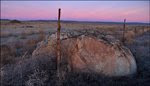
A few erratic boulders sit on Babcock Bench. The boulders were rafted to the area in icebergs during Ice Age Flood events. Today they look out of place in this land of dark brown basalt.


One of the nice scabland features found along the way. This mesa stands high above the Columbia River in the Sunland Estates area.


Fluted gravel bar shown is part of a much larger bar just below point where the river channel makes a slight turn to the east (see next image to view entire bar). This fluted portion of bar is just below and left of red circle #2 - next image.


1. - Sunland Estates
2. - Huge gravel bar (pictured above)
3. - Potholes Coulee


Google Maps terrain image shows hiking route between Frenchman Coulee and Potholes Coulee. I walked cross county going north and followed the old jeep road on return trip.


Several interesting cross canyons (running east to west) cut into the Bench, allow for a look at the basalt flows you've been walking on.


Erratic


I guess if I'm going to stand in these for scale, I should get closer. I think this erratic must be about five feet wide. View north up bench. Great description of Babcock Bench hikes and photo of this erratic in Bruce Bjornstad's book "On the Trail of the Ice Age Floods". Notice the job the floods did scrubbing the bench. I bet this place is covered with bitterroot in the spring.

Erratic sits at N47.0883 - W120.0151


A couple small waterfalls are found between Cave B and the Columbia River. Sad face at left edge of basalt.


Quiet today as I walked by the Gorge Amphitheatre. Stroll by this place at certain times of the year and you could be listening to a rock band and 25,000 fans.


Google Earth view

1. Gorge Amphitheatre
2. Flood Bar
3. Center-Pivot Irrigation
4. Sunland Estates


Fall color in another east-west canyon cutting through bench.


1. West Bar (Giant Current Ripples)
2. Potholes Coulee


The big overhang in the south alcove of Potholes Coulee. Time for a quick lunch before heading back. If you haven't explored Potholes Coulee you're missing out ... This is one of the most amazing places (Top 5) in the entire Ice Age Floods region.

Here's a link to a paper on Potholes Coulee:
The Geomorphology of Potholes Coulee, Quincy Basin, Washington by Marc Fairbanks. A pleistocene sloth that was dug up on Babcock Bench is mentioned.


Interesting piece of basalt with plenty of gas bubbles (vesicles). Looks like it was really tumbled to have such a rounded shape.


The floods left some unfinished business here. The next flood or two shouldn't have much trouble bringing down this huge piece of entablature now that floodwaters can work all sides.


This is one cool pile of rocks. The photo doesn't do it justice ... Looks great when you can walk around and view from all angles.


This was a nice viewpoint. Easy access from another column just out of frame at right.


These hedgehog cactus are one of my favorites. Pretty healthy population of them on the other side of river. Their pink blooms in the spring are great!


Name for this island?


I followed a small stream down to the Columbia. A few salmon were swimming at the mouth of the creek. Some had expired and were scattered along the shore. Long trip from the Pacific ... I hope this was his destination.

The winery has done a nice job marking several trails below the facility.

Cave B Inn from the bench. I'm not sure if it will be there when you click on it but ... The day I posted this, the site had a great sunset photo of Babcock Bench at Cave B / Sage Cliffe.


Use your mouse to navigate around map.


WDFW driving directions to Potholes Coulee and Frenchman Coulee. Release below involves access to Potholes Coulee.


Scabland Gang Activity?
Columbia Basin Wildlife Area - Press Release
Quincy Lakes

Continuing gang-related vandalism is prompting early closure of an entrance gate to the Quincy Lakes unit of the Columbia Basin Wildlife Area in Grant County.

The Washington Department of Fish and Wildlife (WDFW) will close the unit’s south entrance gate Aug. 24. The north entrance will remain open.

The south gate closure is in response to gang-related graffiti tagging, garbage dumping and destruction of public property, including toilets, concrete walkways, parking areas and signs. Closing one entrance gate is expected to reduce unpermitted through-traffic on the north-south road through the unit. That road is traditionally closed to motor vehicles Oct. 1 through Feb. 28 during hunting season. Foot traffic is allowed year-round.

The south entrance will remain closed indefinitely. Wildlife area users are encouraged to report vandalism and any other illegal activity to local law enforcement.

For more information contact WDFW’s Northcentral Region Office in Ephrata at (509) 754-4624.

Wednesday, October 14, 2009

Palouse Falls and Palouse River Canyon - Whitman County Side


Hikers enjoy lunch break at Palouse Falls.


The Ice Age Floods from Glacial Lake Missoula and other sources carved the Palouse River canyon and created spectacular Palouse Falls.

I felt fortunate to be allowed to join a group of six other Ice Age Floods enthusiasts on a hike along the east rim of the Palouse River Canyon. The area is privately owned and has been maintained in a pristine condition by a family that obviously appreciates this unique and spectacular landscape.

Lloyd Stoess organized the hike and arranged for our entry with the landowner. I can't thank him enough for letting me tag along. The arrow-straight upper channel of the Palouse River Canyon and Winn Lake Canyon are Ice Age Floods features I've always wanted to view.


- Click any image to expand -


Our hike began in the rolling Palouse hills several miles east of the canyon. These windblown loess deposits on top of the basalt, have accumulated at depths up to 250 feet. This image was taken near the margin of a huge channel swept by the Ice Age Floods.

Wheat farming ends where the floods stripped away the soil. Mounds shown beyond the wheat are Streamlined Palouse hills that withstood the floodwaters. These large mounds are erosional remnants of Palouse hills.


Another Streamlined Palouse hill along our route. Note exposed basalt bedrock between fence and loess island.

I found the quote below in geologist Bruce Bjornstad's book "On the Trail of the Ice Age Floods":
"The 'islands' of loess which make striking features on many broad scabland tracts are almost invariably elongated with the gradiant of the tract and are almost invariably scarped on the sides and upgradient end ... Many such hills or hill groups are separated by narrow scabland channels. Some stand alone in the scabland, miles from others of their kind."

J Harlen Bretz (1928)


View east - back to the wheat fields.

In early October, Findley Lake looks better on the GPS and maps than it does in person.

  1. Findley Lake

  2. Animal trail to seasonal water

  3. Scabland

  4. Palouse hills east of channel


Google Map terrain view shows one of the Streamlined Palouse hills in the area. Use mouse to navigate map.


Lloyd leads the group through several miles of scabland on our way to the Palouse River Canyon.


I shot a few short videos during the hike. Click arrow to play. Sorry I'm not very steady with the camera. The tripod was home in closet.


Amazing place when you try to visualize the floodwaters that created these features.


The floods scoured out many depressions in the channel that today serve as seasonal water sources for livestock and wildlife.


Google Earth view of the upper Palouse River Canyon. Note deep tectonic fractures in the area that were eroded and scoured out by the Ice Age Floods. The view in this image is to the north ... Arrow marks Palouse Falls ... Washtucna Coulee runs east to west at top. During some Ice Age Flood events, Washtucna Coulee was too small to carry the floodwater. When the torrent overtopped the coulee rim, it flowed south to the Snake River carving the Palouse River Canyon.


Another Google Earth image. View looking south from Washtucna Coulee. The straight 4.5 mile trench in the upper canyon sure is facinating.


View from canyon rim looking north - Up the 4.5 mile trench.


Railroad bridge in upper canyon.


Union Pacific equipment on west side of canyon. Bruce Bjornstad hiking along east rim.


Geologists Bruce Bjornstad and Gene Kiver patiently answered our questions about Columbia River Basalt and the Ice Age Floods.


Laminated deposits on the right confused me. I was behind the group when I noticed these.


View of Palouse Falls State Park viewpoint from behind falls.


Here's a shot for Tyler Bradt in case he finds this page. The flow on the day of our hike was much lower than it was when he made his 186-foot kayak drop off the falls to set a world record earlier this year. Link at bottom of this page to interview where Tyler describes his thoughts as he went over the edge.


Not the best lighting with half the falls in shadow.


View across canyon to Palouse Falls State Park viewpoint. I'm standing in line with a fracture in the basalt that's been scoured out by the floods (large cracks on both east and west rim of canyon line up).

The terraced inner-canyon is pretty amazing. The Palouse River Canyon and nearby Devil's Canyon are good locations to examine Columbia River Basalt flows.


Canyon resident


South of the falls we found several interesting basalt towers.


Hikers stand below group of columns that withstood the floodwaters.


Lone column along canyon rim.


Winn Lake Canyon is an incredible Ice Age Floods feature. A classic example of a flood carved coulee. Walking into Winn Lake Canyon was my favorite part of the hike.


Another shot of loess islands in the channel.


Hikers (bottom left) walk around the upstream end of a Streamlined Palouse hill on our way back to the wheat fields.

The glossary in Bjornstad's "On the Trail of the Ice Age Floods" describes loess as:
Windblown silt and fine sand that has collected downwind of sedimentary basins along the floods route, especially in the Palouse country where it accumulated into rolling hills up to 250 feet thick. Loess began forming about the same time as the earliest Ice Age Floods (about 2 million years ago) and continues to form today.


Images below (2) show examples of windblown loess in the Columbia Basin.


Image recorded by NASA on 4 October 2009. Blue circle marks Pasco, WA.

Arrows label Moses Coulee (1), Grand Coulee (2), Telford-Crab Creek (3) and Cheney-Palouse (4) Ice Age Flood tracts that are well defined in this high altitude image.

NASA TEXT: Visibility dropped to zero in parts of eastern Washington on October 4, 2009, as a large dust storm blew through. This image of the storm was captured by the Moderate Resolution Imaging Spectroradiometer (MODIS) on NASA’s Terra satellite shortly after noon (Pacific Daylight Time). According to local news, the storm brought strong winds gusting to 43 miles per hour in places that propelled the dust across the southeast corner of the state. After numerous multi-vehicle accidents, sections of Interstate 90 near the town of Moses Lake and several local roads had to be closed for several hours.
The dust storm persisted for several hours and was still visible when Aqua MODIS flew over the region at 2:00 p.m. local time. The Terra MODIS image shown here is available in multiple resolutions from the MODIS Rapid Response System.

Open large 7 mb NASA Image of dust storm.


Dust Devil


GPS track shows 14 mile hike route. Thanks again Lloyd!!!


At least I know where Hooper is.


These two patrol the streets of Hooper. Bruce has a story about the big one.


The fractures are pretty distinct in this Google Map terrain view. About five clicks of the "Right" arrow will shift view to the Streamlined Palouse hills shown in several images above.


One more look over the lip of Palouse Falls. I'm so impressed with Tyler Bradt's trip over the falls! Link to Tyler Bradt interview below.


Click above to play interview with Tyler Bradt that describes his world record kayak drop over Palouse Falls.

Link to images and photos of Palouse Falls in winter.

Link to images and photos of Palouse Falls near flood stage.

Link to USGS Palouse River flow at Hooper.