On Saturday, I explored south of Clarkston, WA (Photos from that area later). After looking at basalt and wildlife near Joseph Creek, I headed back to Clarkston then south on US-95 to White Bird, Id.
From White Bird I followed signs to Pittsburg Landing and drove down to bottom of canyon. Plenty of elevation change on the way as you need to cross Salmon River drainage before descending into canyon.

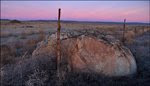
View upstream from Suicide Point in Hells Canyon. Huge gravel bars (terraces) created during Bonneville Flood. -Click any image to expand.


Amazing to be viewing backflooded Missoula deposits so far from Wallula Gap. Even more amazing to find Missoula deposits at Snake River mile 215!!! Yep ... Missoula material is found at Pittsburg Landing. The Idaho Geological Survey map explains that the deposits found at Pittsburg Landing may be the farthest upstream recorded Missoula deposits. Lake Lewis was HUGE!
I was down here to look at flood evidence from from the Bonneville Flood but once again found myself also looking at incredible features created when the massive glacial lake in Montana drained.

Painting by Byron Pickering. View Byron's "Ice Age Flood" video story.

Canyon rim above Pittsburg Landing. Hells Canyon is recognized as North America's deepest river gorge.

Allow plenty of time to travel between White Bird and the Pittsburg Landing. Speed limit 25 mph, grade up to 16% in some places. My map had warning on road - "Steep, winding road. Good transmission and brakes vital".
I found road to be in very good shape.
Open Hells Canyon National Recreation Area page for hiking and camping information.

Giant Current Ripples are found on Upper Pittsburg - Red box locates ripples shown in next image. Looking south - upstream. Idaho/Oregon border.

Click arrow to play short video from trip. About 25 seconds into video, you'll see deer (for scale) grazing on Pittsburg ripples.
View Larger Map
Pittsburg Landing giant current ripples - center of image. Use mouse to navigate Google imagery.


View of Pittsburg megaripples from the other side of river. Photo by Keegan Schmidt (Assistant Professor Geology - Lewis-Clark State College).
Open Keegan's - Virtual Tour of Hells Canyon to view several other interesting features near Pittsburg Landing.

Boats at Pittsburg Landing launch. Note huge Bonneville flood bar.
Area Missoula and Bonneville deposits are shown on Idaho Geological Survey map: Grave Point Quadrangle. Large file ... Pittsburg Landing shown on map at lower left.

Long history of man at Pittsburg Landing. Pictographs and petroglyphs are found at many locations throughout the canyon.


USFS text: "The Snake River National Recreation Trail # 102 follows the.Wild and Scenic Snake River of Hells Canyon for nearly 27 miles. The trail crosses large river bars, climbs over steep rocky outcrops above the river, and is close to the shoreline at times. The river is within your view while hiking the majority of the time. Visit the Kirkwood Historic Ranch and Museum located approximately 6 miles up river from the trailhead. Experience the old homesteads in the canyon. View prehistoric pictographs left by ancient cultures along the trail. Hells Canyon is also one of Idaho's premier places for viewing wildlife and wonderful early spring wildflowers."

I crossed paths with these guys about halfway between Pittsburg Landing and Kirkwood. They're featured in Youtube video above.
 In many places, the trail is cut into rock. River along trail is beautiful.
Snake River Trail #102 is in excellent condition. ... but ... Poison ivy is thick in some areas and ... if you hate snakes ... maybe hike earlier in the spring.

Arrow marks historic Kirkwood Ranch located near the mouth of Kirkwood Creek. I visited the ranch several years ago (by boat) and enjoyed looking at the collection of old farming equipment.

Kirkwood Ranch is a popular lunch stop for tour boats. The small museum/visitor center is interesting (some great photos of early canyon residents). It was nice to hit ranch while iris garden was at peak bloom


I wasn't here to "End it all" ... I was here for the great view of Big Bar (Bonneville Flood). I'm not aware of anyone jumping off the point. Reading trail history, it sounds like some early trail users were nervous when riding horseback around the point - before trail was widened.


Looking back from south end of Big Bar. Note small airstrip on lower bar.
Big Bar airstrip gets some traffic. Plane in video was the only one I saw all day. Pilot landed and took off about 15 minutes later.
If you're interested in aviation, you might like Youtube video posted by lameusernameguy embedded at bottom of this page. Cool approach into Salmon Bar with rock walls out all windows.

This sickle bar mower is one of many farm implements left on Big Bar. At one time, 13 acres of alfalfa were grown on top of the bar and a large sheep operation was established on the lower bar.


USFS Geology of Hells Canyon Page describes huge terraces in this part of the canyon:
The spillover of water from Lake Bonneville at American Falls, Idaho, 15,000 years ago, had an enormous effect on the canyon as we see it today. The volume of water during this event was at least 1,000 times greater than during present spring run-off levels. This tremendous.flow did not deepen the canyon, but it did increase the width of the canyon and formed the large terraces seen near the mouth of Temperance Creek, at Johnson Bar, and at Pittsburg Landing.
These terraces formed on the upstream side of temporary natural dams. Water velocity decreased behind the dams, allowing sediment to fall to the lake floor. Continued down-cutting by the river formed a channel through the sediment, leaving behind the flat terraces.
View Larger Map
Google Earth view of canyon (above my turnaround point) looking south. Drag image around and travel upstream to Hells Canyon Dam. Gravel face on bar at bottom of Google Earth image is the same feature visible in distance in photo of me at turnaround point.
Click above to play video by one of the Hells Canyon tour operators.

While looking at early photos in the Kirkwood Ranch museum, I noticed the old Suicide Point sign on display.

View shows Snake River pinched between canyon walls below Pittsburg Landing.

Annual trail run is held in the spring between Hells Canyon Dam and Pittsburg Landing. I sure liked the hike Sunday and hope I can make the long run with the group next year to see the rest of the trail. A boat ride up and a 31 mile run/hike back sounds like a great (and very long) day. GPS told me Sunday hike was just over 21 miles.