Sunday, March 8, 2009

Lower Crab Creek Coulee - Buttes, Mesas and tsmee-toos?

This early March hike took me by two clusters of buttes and mesas in the Lower Crab Creek Coulee.

Several of these mesas may have been used as defensive positions by early Columbia Plateau residents. Mesas occupied by Native Americans were known as tsmee-toos by the Sinkiuse. The Lower Crab Creek Coulee features shown were shaped by Ice Age Floodwaters and the Columbia River.

Columbia Basin Wildlife Area
Lower Crab Creek Unit


Click any image to enlarge


In 1973 amateur archaeologist Nat Washington released a report titled "Mesa Top Cliff Dwellers of Eastern Washington". Washington found evidence that Native Americans occupied the tops of at least 55 mesas in the Columbia Basin at some period. The sheer basalt walls are thought to have provided protection during attacts.
Ladders may have been used to gain access to the mesa top and would have been pulled up once the group was in position.


Native Americans living in the Columbia Basin have used the lower Crab Creek drainage as a travel route for thousands of years.


The Saddle Mountains rise sharply and form the coulee's south rim.


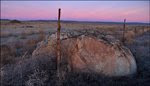
Huge basalt boulders scattered below the coulee's north rim.


View from north rim, looking east up the massive coulee.


View from north rim of coulee.


Wahatis Peak in the distance.


This butte is surrounded by red-winged blackbird habitat. March is a great time to view birds in Lower Crab Creek Coulee.


Aerial view of organic fields on the Smyrna Bench. Arrows mark Lower Crab Creek Coulee. The mesas and buttes shown above are marked by the last two arrows.


If you slow down to study any one image in this post ... I hope it's this one.

Geologist/Author Bruce Bjornstad created this map showing the path of the Columbia River when the Okanogan Lobe of the Cordilleran Ice Sheet was in place. Bruce has marked Lower Crab Creek Coulee with the number 38. It was a combination of the Ice Age Floods and this Columbia River diversion that shaped Lower Crab Creek Coulee.

If you have a few minutes --- Click the map below to enlarge and follow the Columbia River's course shown on Bruce's map in Google's terrain view. The old river channel is easy to trace through the Drumheller Channels, Moses Lake area (Big Bend) and up through Rocky Ford to the Lower Grand Coulee.


This shot looking NE to the upper coulee, was taken several years ago from the Smyrna Bench.


It sure is neat to see the work done by the floods scrubbing away basalt. Where remnants of the upper basalt flow remain in the form of buttes and mesas, it's interesting to note well-defined moats sometimes present on the upstream side.


Interesting balanced rock in the distance.


Should have ended up with a better shot of the rock. Saw no hope of getting on top of the rock before my 20 second camera delay expired.


One of two sharp summit basalt formations in the area.


Local deer seem nervous.


Red-tailed hawk soars above the north coulee wall.


Looking SW into the west end of the huge coulee. Try to imagine the dust stirred up in 1906 when 5,000 wild horses were rounded up between the Saddle Mountains and Ephrata. Newspaper reporters from as far away as the Boston Herald were sent to cover the event known as the Last Grand Roundup.


The Lower Crab Creek area was important to early ranchers that raised cattle and sheep. This display of equipment used by these men is located in the Wanapum Heritage Center a few miles up the Columbia River from the mouth of Crab Creek Coulee.
Wanapum Heritage Center


Lower Crab Creek Coulee could one day be used to store irrigation water. USGS image above (note Columbia River at left).

The Bureau of Reclamation and Washington State Department of Ecology are exploring several coulees created by the Ice Age Floods for additional off-channel storage of Columbia River water. Lower Crab Creek Coulee is high on their list with a potential active storage capacity of 2,300,000 acre-feet. Columbia River Basin Storage Options

Link to: Columbia River Mainstem Storage Options, Washington Off-Channel Storage Assessment Pre-Appraisal Report (Large File 7.4 MB pdf)


With transmission lines already in place and a reliable wind on the Saddle Mountain crest, the ridge looks like a windfarm waiting to happen.


This photo was taken pretty close to the point that I turned to the north and climbed up on Dry Island.


Marsh area near the Clementine Lake trailhead.


Plenty of room to roam on the refuge. This hike was just over 20 miles.

The next two images are from the Drumheller Channels north of Othello.


Deadman's Bluff

Over the years, buttes and mesas created by the Ice Age Floods were put to other uses. This large mesa along the Morgan Lake road in the Drumheller Channels has a gentle slope on the south end (this view from north).

The mesa was once used by local cattlemen as a sort of a "Corral in the sky" for their herd. The cattle were driven up the south side and one or two men were all that was needed to keep them on top. One April night in 1880, 15-year-old Edward O'Rourke was assigned the job of keeping the herd on the mesa. At some point during the night, Edward and his mule tumbled off the east side to their deaths. A rock-pile marker visible from the road marks the point of impact.

The mesa is known today as Deadman's Bluff and the nearby lake used to clean Edward up before he was returned to his parents is Deadman Lake. (Lake located just SW of the Morgan Lake - McManamon intersection)

Former Land Manager of the Columbia National Wildlife Refuge Ron Anglin has written an excellent book on central Washington history that includes descriptions of the Last Grand Roundup, tsmee-toos, and O'Rourke's tumble off the mesa. Forgotten Trails


Washington found that one of the characteristics of mesas used as defensive positions was a reliable nearby source of water. I need to catch up with Washington's report to see if this Drumheller Channel mesa along Crab Creek made the list of 55.


Click to open WDFW's: Lower Crab Creek Unit - Detailed Land Ownership & Resource Map

Eagle perched above Columbia River near Wanapum Dam.


View Larger Map

Note tiny Crab Creek wandering through the massive Lower Crab Creek Coulee. Use your mouse to navigate map.

Links to Lower Crab Creek trip reports posted by others:

Crab Creek Wildlife Area Hike

Seattle P-I Hike of the Week

Sunday, March 1, 2009

Ice-Rafted Erratics in Jackknife Canyon


This huge granite boulder was floated to this location aboard an iceberg during one of the Ice Age Flood events that swept over eastern Washington near the end of the most recent Ice Age.


In late February I visited two of these large erratics above Jackknife Creek after hiking north from the Rocky Coulee parking area near the Gingko Petrified Forest State Park visitor center. Later in the year it may be easier to access the Jackknife Creek area via the green dot road system for those that don't mind a bumpy ride using high clearance vehicles, motorcycles or perhaps a rental car.


After crossing the State Park, I entered the Whiskey Dick Unit of the L.T. Murray Wildlife Area. This is wide open country with both erosional and depositional Ice Age Floods features to explore. If you head out here to visit the big erratics make sure to pack a lunch. The hike ended up covering 20.7 miles.


The largest of the Jackknife Creek erratics is visible from Frenchman Coulee. When visiting Frenchman Coulee, take a few minutes to explore the west side of the river with your binoculars. The floods really did a job on the basalt over there.


From Bruce Bjornstad's book:
On the Trail of the Ice Age Floods

"Of special interest is a high, sculpted-out area in the steep wall of basalt visible on the opposite side of the Columbia River from Frenchman Coulee. Like a giant fire hose, a forceful jet of floodwater hit this rock wall head on after cascading through Frenchman Coulee."


As soon as you start hiking across the State Park land you'll see plenty of ice-rafted erratics scattered over the landscape. This part of the state has been covered by dark brown Columbia River Basalt so granitic boulders are often visible from great distances.


The flood sculpted terrain along with the material deposited by the floods are enough to get me out here. Viewing the petrified wood is a bonus.

Hard to select just a couple petrified wood shots to post. I took quite a few during the hike.


So much petrified wood out here that the guys setting this benchmark in 1957 pressed some into the concrete.

Petrified Log


I sure enjoyed the view as I walked north high above the Columbia River. Locations marked on photo are: 1. Sunland, 2. Babcock Bench, 3. Frenchman Coulee, 4. Interstate 90. Click any of the photos to enlarge.

Degree Confluence

A destination for some is out there on the surface of the Columbia River: 47°N 120°W


I'm not sure what I was thinking when I decided to cross the Hole In The Wall drainage rather than walk around the west end. It sure ate up the time and I didn't find much of interest down there other than a small cave.


As I was trying to work my way down to the river I saw this guy to my right. He was looking down the river and didn't realize that I was behind him. As soon as my camera clicked he gave me this profile view and then took off.


Wish I could have spent more time at:

N 47°00.411'

W 120°00.482'

Some nice basalt exposures in all directions.


Walking on top of the columns.


Moss covered petrified log.


Leaving the hike for a minute here. Wanted to mention that I visited the Yakima Museum's new Miocene Forest exhibit a couple weeks ago. The museum page notes that geologist Nick Zentner (Ellensburg IAFI chapter President) was one of the experts consulted in the development of the exhibit. The display is beautiful and helps tell the story of the forest that existed here 15 million years ago.

The museum's Time Tunnel exhibit provides information relating to the Columbia River Basalt Group, the Ice Age Floods and some of the animals that once inhabited the area.


Antlers near Cayuse Creek

Many deer (like the one that wore these) use the Whiskey Dick Unit but the animal the area is known for is the Rocky Mountain elk.


COLOCKUM ELK HERD

This area is important winter and early spring habitat to some of the 4,500 animals that make up the Colockum Elk Herd. The link opens a 58 page document that describes the herd including a description of the strategy used by WDFW to manage their population on the West Bar (Giant current ripples).


The WDFW herd history states that the main Colockum herd developed from 45 Montana Rocky Mountain elk released near Boylston and driven north at Vantage in 1915 (Pautzke, 1939). Zooarchaeological data from the Columbia Basin suggest elk were present and utilized by early inhabitants (McCorquodale 1985, Dixon et al. 1996). By the late-1800s elk may have been extirpated from the Region (McCorquodale 1985). The current Colockum elk population
developed from the reintroduction of Rocky Mountain elk (Cervus elaphus nelsoni) from
Yellowstone National Park in 1913 and 1915, which significantly contributed to any remnant animals in the area (Bryant and Maser 1982).


Frenchman Coulee


These small current ripple marks in the sand caught my eye along the Columbia River (note footprints for scale). They reminded me of ripple marks on a much larger scale created a few miles to the north by the Ice Age Floods.

This photo of the giant current ripples on West Bar was taken just before sunset in June. Some of the West Bar ripples are 24 feet in height and 360 feet apart. Geologist believe the water that created these ripples was 650 feet deep!


I like seeing the suitcase size erratics but I was anxious to see the large one I'd spotted from Frenchman Coulee.


Cluster of small erratics, Frenchman Coulee in the distance.

The smaller of the two large erratics above Jackknife Creek. Note: Columbia River in the distance.


Another view of the erratic shown in the previous photo. Arrow identifies the large erratic I viewed from Frenchman Coulee.


Hard to believe this 9' tall rock floated into Kittitas County.


Could be the top of a 30 footer?


Many sections of the green dot roads near the river are cut into flood deposits.


Area Roads Closed Until May 1st

A closure to motorized vehicle access on the Whiskey Dick and a portion of the Quilomene wildlife areas in Kittitas County is in effect from February 1 through April 30 during 2008 and 2009 to protect wintering elk. The area is north of the Vantage Highway, south of Quilomene Ridge Road, east of the Wild Horse Wind Farm, and west of the Columbia River. The effectiveness of the closure will be evaluated at the end of that period to determine whether it should become permanent.


Anyone know what kind of bird this is?

Tom Email


On my way back to the car I spent some time looking at Sentinel Gap. This restriction probably had a lot to do with the location of many erratics in the Ginkgo area.

The movie below is VERY low quality but it does show views of the large erratics above Jackknife Creek:


Links to December 2008 hikes at Ginkgo Petrified Forest State Park:
Ginkgo State Park Part I

Ginkgo State Park Part II