I'll try to follow this post with shots from the Vantage, WA area along with a few from the lower Grand Coulee.
Sorry I've been slow to post images from hikes. I still like to get out in the spring and fall ... Just not getting around to posting.
Click any image to enlarge.

Bruce Bjornstad on Umatilla Rock (Sun Lakes-Dry Falls State Park).

Flood-swept basalt plateau and small portion of Dry Falls cataract system. Hikes over the weekend covered flood features between Sun Lake-Dry Falls State Park and Northrup Canyon.

Bruce inspects flood deposits (sand and gravel) beneath layers of slackwater deposits that settled to the floor of Glacial Lake Columbia.

The Grand Coulee is a great place to view Columbia River Basalt.

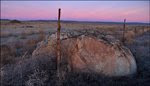
This ice-rafted erratic has been put to work holding a Grand Coulee fence post.

When you see signage that includes these towns ... You're getting close to some of the best features in the entire Ice Age Flood region.
The Coulee Corridor group maintains a nice website that describes this section of SR-17. Click link to visit its site.
It possesses almost every characteristic feature of scabland, and most of them are on the huge scale consistent with the flood conception.

J Harlen Bretz called Northrup Canyon a "Very peculiar tributary" in his 1932 guidebook "The Channeled Scabland".

Canyon leaves were beautiful. Loved the reds and yellows around lake. Heart-shaped lake photo for Teresa.
Open link to visit Bruce's Northrup Lake geocache page. Great text and illustrations!

The canyon is amazing ... You're near the edge of the Columbia River Basalt Group flows (not very thick up here). At this location the floods have ripped away basalt and exposed underlying granite.
The granite is significantly older (50-100 million years) compared to the basalt which is only 15-17 million years old.
"One can stand on the brink of Northrup Canyon and aver with confidence that it can never be satisfactorily explained except as an extinct Niagara."
J Harlen Bretz 1932

I like this Google Earth image showing the granite ridge. Aerial images on Bruce's geocache page show grooves and potholes on the plateau.
Bretz noted "Buried granite hills exhumed by erosion of the glacial torrent are also seen" when describing Northrup Canyon.


Click arrow to play short aerial video by GeoCosmicREX. Footage shows upper Northrup Canyon - Check out granite ridge - canyon center. Northrup Lake visible about 20 seconds into video.

Bruce will have a new Ice Age Floods guidebook out soon - Published by Keokee Books. I hope it comes out soon. The Grand Coulee guidebook I'm currently using was published in 1932!
Awesome cover art by Stev Ominski shows Dry Falls area (includes Okanogan Ice Lobe and receding Ice Age Floodwater).

The Bureau of Reclamation has lowered Banks Lake 30 feet to perform maintenance on equipment at Dry Falls dam. Lots of mud and sand exposed in the Grand Coulee. This shot shows mud flat between Steamboat Rock and mouth of Northrup Canyon. Note Glacial Lake Columbia deposits being blown around (arrow).


I thought it might stink but there was no odor. The mud/silt/sand didn't really stick to shoes - Enjoyed walking around out there.

It was easy to get around and explore Glacial Lake Columbia deposits.

1. Dry Falls Visitor Center.
2. Umatilla Rock.
3. Deep Lake potholes.
4. Dry Falls Dam.
5. Coulee City.
6. Main Canal (Columbia Basin Irrigation Project).

The road to Deep Lake is closed this time of year. Easy walk or bike ride to lake and pothole area.

OK ... The plan was to try and get a better angle with camera when photographing Deep Lake potholes. Before I waved my Nikon around on a 16 ft. pole - I supplemented the attachment point with several wraps of duct tape.


The potholes out here are really cool! Whirlpool-like currents called kolks, drilled into the basalt.
View from the top of a Lowe's 16' telescopic painter's pole. Looking west down Deep Lake channel to Lower Grand Coulee. Bruce standing near pothole rim (left).

Here's a strange place Bruce heard about from Mark Buser (Ice Age Floods Institute President).
A short tunnel allows easy access to the pothole floor.


View over pothole with tunnel entrance (red diamond). Bruce standing on wall between lake channel and pothole.


Google Earth image shows tunnel entrance pothole (1) and pole photo pothole (2).


That's Bruce and he's ... "On the Trail of the Ice Age Floods".
No trail to the top of Umatilla Rock ... just a talus slope with some scrambling near the top.

Confluence of Monument Coulee and Deep Lake Channel in the distance.

Three images here show view into flood-scoured Monument Coulee.

I like the rubble rings around some of the giant basalt boulders. Rings probably formed as smaller blocks broke away from the biggest boulders due to post-flood freeze-thaw activity.


Bruce explores the top of Umatilla Rock. Nice views from up here. What an amazing place!
When you view the floor of Monument Coulee from the top of Umatilla Rock (or hike in the coulee) you may notice several large granite boulders.

Large granite boulders near our home in the Pasco Basin were rafted within icebergs. Many found near Dry Falls were transported in the bedload.
Cool video posted by SRGSclips - Click to play. Shows bedload movement in lab flume.

After watching lab video above ... Extrapolate out and replace flume with The Grand Coulee and multiple Ice Age Floods. Boulders this size would have easily moved through the coulee without the aid of ice.

Many flood bars in this area are covered with large boulders - "Armored bars".


Next time you visit Dry Falls - Make sure to take a few minutes to walk through the Visitor Center. The ranger that smiles and says "Hello" is Maurya.

Maurya can tell you about the basalt wall in Monument Coulee.
Dates and Hours from State Parks site - November 2011.
Dry Falls Visitor Center summer hours: May 1 - Sept. 30, 9 a.m. to 6 p.m. daily
Dry Falls Visitor Center winter hours: Oct. 1 - April 30, 9 a.m. - 5 p.m., closed Thursdays
Dry Falls Visitor Center is closed on the following holidays: Veterans Day, Thanksgiving, Christmas, New Years Day, Martin Luther King Jr. Day and Presidents Day.

Google Earth view - Niagara Falls

Google Earth comparison: Dry Falls - Niagara Falls.

If you plan to explore Ice Age Flood features in Washington State - you'll need one of these. I'll bite my tongue and move on to the next picture.

Walked by this interpretive panel that shows Teresa standing in front of flood-cut caves used by early residents of the area. Floodwater at top of image by Stev Ominski.


Samuel Adam's Octoberfest tasted pretty good at Couleegan's in Coulee City.
Wanted to try The Banks Lake Brew & Bistro for coffee but they don't open until 0900 on Sunday. Good thing the friendly folks at Big Wally's have their "Shut Up and Fish Blend" brewed early each morning.

A giant sign that says "MO" is just across the street from coffee stop.
Short Dry Falls panorama (video) shot earlier this year. Click arrow to play.
If you have a little time - Click to watch CWU's Nick Zentner interview Bruce on Central Rocks.
Link to Umatilla Rock blog images posted a couple years ago. Spring trip to Dry Falls area. Deep Lake pothole views from rim.