I didn't see everything I wanted to on this hike. The short November day flew by.
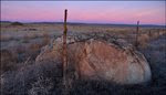
Victoria Rock
Victoria Rock - An interesting basalt tower standing in the Columbia River channel that's withstood plenty of abuse by floods over the years.

I mentioned Lieutenant Symon's "Report of an Examination of the Upper Columbia River: And the Territory in Its Vicinity in September and October, 1881" in a recent post of Sentinel Gap area photos. In his report, Symon's describes Victoria Rock:
A few miles further down there stands in the Columbia River a rock which is one of the most perfect profile rocks in existence. Approaching it from the north, it presents a striking likeness to the profile of Queen Victoria, from which circumstance it was given the name of "Victoria Rock."
Coming nearer to it and passing it on the west, the profile changes and merges into a more Grecian and Sphinx-like face, whose placid immobility takes one's mind involuntarily to far off Egypt. It rises from the surface of the water about one hundred feet, and a pair of eagles have selected it as their home, and upon its extreme top have built a nest, giving, as it were, a crown to this goddess of the Columbia.
The rock is of columnar black basalt. The portion of the river in which this rock is situated is very grand and beautiful.
Lieutenant Thomas William Symons (1881)

There it is ... Victoria Rock. Right where the Lieutenant said it would be.
Construction of Wanapum Dam south of Vantage, was completed in 1963. Only the uppermost portion of Victoria Rock stands above today's reservoir level.
It took an early start from Pasco to begin hiking before sunrise. I had to drive all the way to Wenatchee, cross the river and then drive south to reach the Tarpiscan Creek WDFW parking area. A Vehicle Use Permit is required in this area.

Click map to enlarge and you should be able to see Victoria Rock below "Cabinet Rapids". Other notations on map from top are Bishop Rock, Sunken Rock, Rock Island Rapids, Bar of Rocks, Bad Ripple, Little Creek and two small bars just above "Flat" at West Bar.
Looks like notation on top of rim west of Victoria Rock reads "Magnificent Columnar Basaltic Bluffs". The area marked "Flat" at lower right is the NW corner of West Bar.
 View northeast over Columbia River to mouth of Moses Coulee. Victoria Rock visible in river at lower right. The huge flood bar on far side of river is the Moses Coulee Bar. Much of the bar is out of frame to right.
I'll try to post Moses Coulee images one of these days. In his book "The Geological History of the Wenatchee Valley and Adjacent Vicinity" Charles Mason states:
"It is the author's opinion that Moses Coulee, above all else, has an atmosphere and character unmatched in our area. One would be hard pressed to find a more inspiring sight than a drive on an early sunny morning through the miles of majestic palisades of the lower coulee".

Tarpiscan Creek Bergmound
Tarpiscan Bergmound - Thousands of years ago, a huge iceberg floated into the Tarpiscan Creek drainage and grounded during one of the Ice Age Flood events. After the floodwaters receded and the ice melted, a large pile the glacial debris carried by the iceberg was left stranded in the canyon.

I hiked up the canyon for several miles enjoying bright fall colors and the interesting basalt cliffs along the north rim. Way too much time was spent taking pictures of frosty leaves and pine cones (above maximum flood level).
I'd had my eye on the big bar that sits between Tarpiscan Creek and the South Fork of Tarpiscan Creek. Once over the top of the bar I spotted a huge bergmound (marked in image above).

Erratic I'm leaning on (#1 in photo below) measured over 12ft. end to end.

Another view of erratics shown above. Note smaller erratics in foreground.
Hope you don't mind if we take a quick trip to the lower slopes of Mt. Rainier.
 Sometimes it's Hard to tell where the glacier ends and the mountain begins.
Glaciers are often referred to as "Nature's conveyor belts". Rocks from adjacent slopes often fall on top the glacier while ice in contact with the earth below the glacier is picking up rocks and other debris. Material carried on the surface of the glacier is known as "supraglacial debris" while the lower part of the glacier carries "basal debis".
The huge glacial ice dams that failed and released Ice Age Floodwaters were loaded with debris. Large sections of the dams were swept away with the flow and carried over eastern Washington. Some of these icebergs would have ridden the floodwaters all the way to the Pacific Ocean but many ran aground in Washington and Oregon. Rocks and boulders transported by the ice are known as "erratics".
er⋅rat⋅ic1. deviating from the usual or proper course in conduct or opinion; eccentric: erratic behavior.2. having no certain or definite course; wandering; not fixed: erratic winds. 3. Geology. noting or pertaining to a boulder or the like carried by glacial ice and deposited some distance from its place of origin. 4. (of a lichen) having no attachment to the surface on which it grows. Source: Dictionary.com |


Ivar Husa of the Ice Age Floods Institute's Lake Lewis Chapter answers the question "How Large Must an Iceberg be to Carry an Erratic" on Page 4 of the December 2005 Pleistocene Post.
 As the iceberg melted, several large boulders rolled down slope. The rocks, gravel, sand and silt aboard the iceberg remained in a huge mound.
Click image above to play what appears to be the first "Bergmound" video posted on Youtube. Video shows relationship of bergmound site to Columbia River.
 Not as many smaller scattered erratics in the Tarpiscan area as there are in other Kittitas County drainages to the south. I did see a few similar to this one as I hiked south out of the canyon.
West Bar Giant Current Ripples
West Bar Giant Current Ripples - Huge current ripples created when fast moving floodwaters swept over the West Bar area. Geologists believe that the West Bar Ripples were formed during one of the last Ice Age Floods - Possibly the final draining of Glacial Lake Columbia.

I started to draw the route I used to get to West Bar on this image but, decided I'd better not do anything that would promote this as West Bar access. I know this basalt face as "Cape Horn".
TIP #1:The animal path I used is above terrace with the big pine.
TIP #2: Don't slip!

West Bar (right). Moses Coulee Bar dipping into Columbia river at left. Thin horizontal line on distant basalt cliff is Babcock Bench.

The Ice Age Floods created many large gravel bars. Moses Coulee Bar is one of them ... Train for scale.

1. Tarpiscan Bergmound
2. West Bar Giant Current Ripples
3. Moses Coulee
4. Crater Coulee - Also known as Crater Draw (No public access).
5. Quincy, WA - City of Quincy's "Local Geology" page.


Click below to view Giant Current Ripples from Bruce Bjornstad's geocache at the West Bar Overlook.
A couple images here of other ripples you might come across as you explore the Ice Age Floods region.
 I noticed these frosty ripples in the sand yesterday while hiking along the White Bluffs (SE of Mattawa, WA). These small ripples were creeated by the wind blowing over the dune.
 Arrow points to hiker standing on one of the tallest West Bar ripples.
Geologists estimate the West Bar ripples were formed between 12,000 and 13,000 years ago. The ripples average 24 feet in height and are spaced about 360 feet apart. It's been estimated that the fast moving water that formed these ripples was about 650 feet deep (Not one of the largest floods).
The day this photo was taken, Orin and I arrived at West Bar in his boat ... which is the easiest way to get there. Certain times of the year you can drive to West Bar ... but ... It's a bumpy trip.
WDFW's description of Colockum area roads:
"Extremely primitive. High-clearance, four-wheel drive vehicles are recommended. Carry water, supplies and a spare tire."WDFW Colockum Wildlife Area - Ownership & Resource Map

I noticed several several erratics as I walked up and over ripple after ripple.
 Large rocks dropped on the crests of giant ripples seem popular with local birds.
 Small elk herd on West Bar (Between the arrows). View is south over western edge of ripples.
 View Larger Map
Use your mouse to navigate Google Map. Click "Ter" for Terrain View.
Additional Comments from the Symon's Report

A few text clips from the Symon's Report related to the Ice Age Floods -
The Grand Coulee:
"The coulee here is partially filled up by the broken-down hills. The cause of this break seems to have been a flood of water or ice coming in from the northeast and flowing off down through the coulee chasm. Many rounded bowlders are here found in the soil, and great rocks of large size, which could only have been transported by the agency of ice."
Victoria Rock area:
... "Thousand feet above the river, there lies in an inclined position a stick of timber, barkless and white with age. It never grew there. It is a thousand feet from the top of the vertical bluffs, and could not have been put there from above. The only way in which it could have reached its present position was by being caught there when the river was a thousand feet higher than it is now, drifting in and lodging, and being left there by the receding river.
My pilot. "Old Pierre," an Indian pilot and voyageur of the old Hndson Bay Company, said that this log was a landmark in the days when this company transported their furs and merchandise up and down the river in bateaux. He says that the Indians always considered that the log was left there when the river was up at that height. This is one link in the chain of evidence that proves that at no distant date the Columbia was a stream of such magnificent proportions that the present river is a tiny rivulet compared with it. If this be the true explanation of the location of this log, it is a remarkable example of the preservation of wood for a long period of time. It may be that the log is petrified, but I had no means of getting at it to determine."

The banks are nearly precipitous bluffs, from 2,000 to 3,000 feet high, composed of columnar black basalt, which takes many wonderful shapes and produces many pleasing effects, rivaling the famous Giant's Causeway of Ireland in weird beauty. The columns are in every conceivable position, sometimes piled up like cordwood, in some places erect, and in others inclined; some great masses are twisted and bent, forming niches, arches, grottos, crowns, &c.
 A View of Giant's Causeway: East Prospect. Engraving. Susanna Drury -1768
ABC News clip featuring Giant's Causeway
Below Sentinel Gap Symon's describes:
I have endeavored to outline this ancient lake as far as practicable, and propose for it the name of Lake Lewis, after Capt. Merriweather Lewis, the leader of the exploring party which first saw any of the headwaters of the Columbia.
 I'd like to encourage anyone that hasn't looked through William D. Layman's book Native River to pick up a copy and thumb through it. The pre-dam Columbia River photos from Priest Rapids to the Canadian border are great!
 Some of my favorite images in the book show: Sentinel Gap, Picture Rocks Bay, Vantage Bluffs, Rock Island Rapids, Victoria Rock and Whitestone Rock (I like the skunk story).
When I read Symon's comments about Columbia River basalt exposures rivaling those at Giant's Causeway (never been there but viewed plenty of photos) ... I was thinking he might be a little off but ... Look at the photos in Layman's book of Picture Rocks Bay (now underwater) ... Between amazing columns and the incredible pictographs and petroglyphs ... I can see why he would compare it to one of the most incredible locations on earth.
Link to photo sets from Tarpiscan Canyon hikers at NWHikers.net.