Balsamroot and lupine near Lake Lenore seemed to be at peak bloom.

I wasn't able to drive straight through from Pasco to the lower Grand Coulee. A side trip through Drumheller Channels led me to an unscheduled hike.
"It is a marvelous region of scabland buttes and knobs, canyoned channels, rock basins interrelated in a complex unparalleled elsewhere, even in the scablands." - J Harlen Bretz 1928

Google Earth vantage point is just north of Soap Lake, WA.
1. Great Blade, 2. Alkali Lake, 3. Blue Lake, 4. Park Lake.
Note huge flood channel east of the Great Blade.

One of many caves found near Lake Lenore. Interpretive display at Dry Falls shows Native Americans utilizing caves for shelter. I've been told that the caves were used like a garage (for storage) rather than shelter. Signage along highway will direct you to an interesting cluster of caves that were formed during Ice Age Flood events.
BONUS: Embedded video at bottom of page was shot in another of the Lake Lenore caves. You'll need to turn on speakers. Thanks for posting video Glen!

I like to park near mile-marker 83 and hike through cut into the east channel. Some incredible evidence of high-energy flooding can be found in this area. Great Blade - top right.
View Larger Map
Check out those potholes! Use your mouse to move around and explore the area.
I usually park between the 17's - Small pull-off (east) just big enough for a couple cars. The guy in your rearview mirror isn't expecting you to be pulling over here. Be careful! The longer gravel parking strip at top left is also available.
Once you get parked, the hike up through terraces to east channel is easy. You'll pass through a fence opening with a WDFW "No Vehicles" sign.

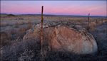
Strange place to find this thing? Angular erratics resting in flood channels isn't something you often find. Several large ice-rafted erratics are located along the east margin of this channel, but this piece of argillite is the largest erratic I'm aware of out near the center of the channel where the bedrock had a hard time sticking around. Great Blade in distance. The boulder does sit on the crown of a basalt formation and must have been carried here on one of the last floods to reach this level.

Several other erratics surround the piece of argillite pictured above. Rounded erratics like this are more typical of what you can expect to find in flood channels containing dramatic errosional features. This type of erratic would have started its journey in an iceberg before dropping into the floodwaters or grounding at some point only to be tumbled in the next Ice Age Flood. Angular corners on bedload carried erratics would have quickly been rounded by impacts with bedrock and other boulders carried in the floodwaters.

Orange star marks argillite erratic in previous photo. Yellow stars identify surrounding granodiorite erratics.

Angular erratics are sometimes found (in high-energy flood channels) wedged in or behind some sort of structure that provides shelter. Earlier in the day I found these angular erratics wedged into a notch in the basalt while hiking near Lower Hampton Lake.

They should be safe here for another flood or two but once the downstream lip of basalt is removed, they'll be introduced to the bedload and headed for lower Crab Creek.

Two examples of typical erratics found in the Drumheller Channels.

Click arrow to play a short video I shot later in the day from the top of the Great Blade. You'll get a better look at the east channel from up here.
THERE IS NO TRAIL to follow if you want to visit the top of the Great Blade. Bretz's 1932 "Grand Coulee" publication led me to believe that I'd find a find a way to the top.
"The highest place on this cliffed ridge is literally a blade of rock, unscalable except at the south end." - J Harlen BretzIt took a little time to reach the southern terrace (some people will not like the route). Once I got up there, all I needed was a little help from "The Watchdog" to stand on top.

Another pothole in the east channel.

The first bitterroot blooms (my favorite wildflower) I've seen this year.

One wall of this pothole has been opened up. Pretty quiet around here today.
Years ago they made some noise in this part of the coulee. Check out the B&W footage in Youtube video below!
Turn speakers on and click arrow if you haven't seen this before (AMAZING).


View Larger Map

Great Blade summit plateau.

J Harlen Bretz featured a similar photo in his 1932 publication "THE GRAND COULEE". Bretz used caption below to describe image:
Ridge between the monoclinal and synclinal channels, lower Grand Coulee. Looking north from the Great Blade. The lake surface is about 250 feet lower than the synclinal channel floor, and the ridge is about 75 feet higher. Hanging valleys west of the lake were once continuous across both lake canyon and ridge to the synclinal channel.


Unless you tell me differently ... I'm guessing Pothole A merged with with a pothole once located at C creating a small channel that will be joined by Pothole B during future floods. The A-C area will then join channel at top right creating Mesa D. Next photos shows examples of mesas lower in the east channel.


Nice elevated walking surface between main channel and pothole.

Great Blade summit plateau. Red arrow points to "Watchdog Rock".
The flowers on this upper terrace were pretty.

Watchdog Rock came in handy as I tried to reach the top of the blade. Once my foot was on the Watchdog's shoulder, I had it made. Pretty cool that he's got a tail.

Not sure why someone felt the need to mark up the Watchdog???

I've always liked the basalt column w/face that looks out over Lower Hampton Lake.

View south to confluence of lower Grand Coulee and east channel. Note elevation difference.

Arrow points to pothole with smooth upper walls. I marked its location on my GPS several years ago. When visiting this area I always take the time to walk over and marvel at the "Polished Pothole". I haven't found another one like it.

My pack sits on rim of the "Polished Pothole".

Bretz wrote about this channel:
The higher eastern channel has cataract ledges across it 50 to 75 feet high, rock basins on its floor 100 feet deep, and a maze of minor anastomosing channels channels and buttes.

Nice clump of flowers thriving on top of the Great Blade.

The floods drilled many incredible potholes into the floor of the east channel, including a couple huge ones at the south end. These potholes are amazing but I still have the Deep Lake area potholes at the top of my list.

Drumheller Channels / Columbia National Wildlife Refuge.

The huge system of scabland channels east of the Frenchman Hills sure stands out in this Google image. Irrigated farmland served by the Columbia Basin Irrigation Project borders the 8-mile-wide Drumheller Channels on the east and west. The Bureau of Reclamation uses several of the channels cut by Ice Age Floods to move irrigation water from the Quincy Basin to the Othello Basin.
1. Potholes Reservoir
2. Othello, WA

Irrigation water fills many of the rock basins and potholes in the Drumheller Channels. The habitat created provides excellent opportunities for wildlife observation to Columbia National Wildlife Refuge visitors.

Google aerial image shows:
1. Pothole near Lower Hampton Lake.
2. Large pothole shown in previous image (foreground).
3. Irrigation channel cut by the USBOR at lower end of Long Lake (shown in next image)

The floods didn't leave channels everywhere the USBOR needed them to move water between the Quincy and Othello Basins.

Pothole near Lower Hampton Lake shown in aerial photo above as "1".

This pothole is impressive to view in person (shown as #2 in aerial above).

White Pelican - Lower Hampton Lake

Signs introduce visitors to parts of the refuge trail system.