 Ice-rafted erratic boulder stranded above Columbia River
(Cayuse Creek drainage, eastern Kittitas County)
NEW VIDEO: Petrified Tree
Each time I visit Frenchman Coulee I find myself looking to the west side of the Columbia River. The Cayuse Creek and Whiskey Dick Creek areas appear to have been blasted by violent Ice Age Floodwaters that swept over the Columbia Basin near the end of the last Ice Age.
Last Sunday I decided to take a loop hike across Ginkgo Petrified Forest State Park to Whiskey Dick Creek then west for several miles before walking back to my starting point. The wildlife, petrified wood and numerous Ice Age Flood features kept me entertained all day.
Most of the images will enlarge if you click them.
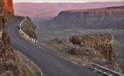 Looking west from Frenchman Coulee

Note: Cayuse Creek on the other side of Columbia River. If you're familiar with "The Feathers" in Frenchman Coulee, the feature is identified in photo.
In his book
"On the Trail of the Ice Age Floods", geologist Bruce Bjornstad points out:
Of special interest is a high, sculpted-out area in the steep wall of basalt visible on the opposite side of the Columbia River from Frenchman Coulee. Like a giant fire hose, a forceful jet of floodwater hit this rock wall head on after cascading through Frenchman Coulee.

Many pieces of petrified wood in the park are only partially exposed.
Ginkgo Petrified Forest State Park is an amazing place. Start with
Columbia River Basalt Group lava flowing into the area from the southeast, building layer upon layer. About 15.5 million years ago some of the basalt in the Vantage area was covered by debris (ash, dirt, rocks, trees) carried by at least one lahar (volcanic mudflow) flowing from the west or northwest. The course of the Columbia River was obstructed and a large shallow lake formed in the Vantage area. The lake held a mixture of water logged trees, some from the Vantage area but many other species carried by the river and lahar(s).
When the basalt flows resumed, water and mud provided protection for some of the trees and prevented them from burning. The lake disappeared under the basalt and the logs were entombed. Water draining through the cooling basalt slowly petrified the logs.
"Ginkgo logs are so well preserved because they were rapidly buried and sealed off from exposure to air. If the logs had come to rest on the surface they would have rotted and decomposed to nothing. But being deeply buried there was no oxygen or animals/microbes for decomposition."
Bruce Bjornstad
So ... We started with basalt flows, then lahars, cover that mess with more basalt, let things cool off for a few million years ... Don't get too relaxed Vantage because here come the
Ice Age Floods!

One of my first stops on the hike was a quick visit to the "Karlson Erratic". This is the largest ice-rafted erratic I know of in Kittitas County. It sits right where the iceberg left it at 1,105' in Rocky Coulee. Ryan Karlson measured it 10' x 8.5'.
There could be bigger ones out there. I just need to find the time to search Tarpiscan, Tekison, Brushy, Quilomene, Box, Skookumchuck and Jackknife canyons along with Dry Gulch and all their tributaries.
 Petrified red gum log exposed by the Ice Age Floods.

I always enjoy walking up to lone erratics and small clusters of erratics in the
Channeled Scablands of eastern Washington but it's really cool to walk up to these bergmounds where a large iceberg has grounded and melted out leaving a large pile of debris. I'll post other images of this bergmound in the future. The view looking south is scenic with Sentinel Gap in the distance. In this shot I'm looking NE.

Aerial view looking north over the Interstate 90 bridge at Vantage.
A. Ginkgo Petrified Forest State Park
B. Cayuse Creek
C. Mouth of Frenchman Coulee
D. Babcock Bench
When crossing the bridge, try to imagine floodwaters 700 feet above the Columbia River surface (Wanapum Reservoir normal pool elevation 570 ft).
 Hiking SE out of the upper Cayuse Creek drainage.

In 1975 the Washington State Legislature adopted petrified wood as the official "state gem". The Wanapums and other Native Americans used pieces of the petrified wood for arrowheads.
 The petrified growth rings are interesting.

Looking east towards the Columbia River. One of the highest Ice Age Flood markers I found.
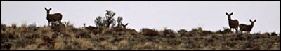 I felt like I was being watched all day.
 Seems to be a healthy cactus population in both the Cayuse and Whiskey Dick Creek drainage. This area receives 8 inches of precipitation annually.

Visit the Mid-Columbia Basin in the spring and check out Hedgehog Cactus blooms.

Another shot from the spring. When visiting Ginkgo State Park in late November, it's hard to remember how beautiful the spring wildflowers are in Schnebly Coulee.

During warmer months I've seen a few of these guys around the park. They always seem to be working hard to get out of the way, but it's a good idea to try and watch where you step.
Warning posted by the State Parks Department:
WESTERN RATTLESNAKE
Rattlesnakes are inhabitants of this area. Although largely active in the evening and cooler hours of the day, they can be found anytime from early Spring through late Autumn.
Rattlesnakes are important predators of birds, mice, rabbits and other rodents. Because the kill their prey by using a deadly venom they can be dangerous to man. Exercise caution in this area.

Vantage area petroglyphs on display at the Ginkgo Interpretive Center.
Humans have used the Vantage area for at least 6,600 years. This part of the Mid-Columbia was known to the Wanapum Indians as
pank'ú.
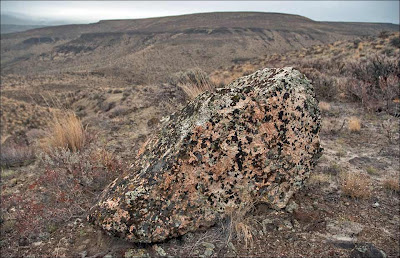 Lichen covered erratic
Erratics have been found at a distance of more than three miles from and nearly 700 feet above the Columbia River at Ginkgo Petrified Forest State Park. Ryan Karlson (Washington State Parks), completed an incredibly thorough inventory of Ice Age Floods erosional and depositional features within the park. During this study he found the highest frequency of ice-rafted erratics above 1,100 feet. The highest erratic discovered in the study was sitting at 1,263 feet.

Another
traveler found in the upper Cayuse Creek drainage. Resting here 15,000 years and still thought of as an out-of-state visitor.
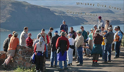
Here's a shot taken in the spring of 2006, during an
Ellensburg Chapter of the Ice Age Floods Institute field trip. Chapter President
Nick Zentner (tan vest - left) tells a story about the
Trees of Stone. Note Cayuse Creek drainage identified in the distance.
THE HISTORY of GINKGO PETRIFIED FOREST STATE PARK
In 1931, geologist George F. Beck of Central Washington College of Education in Ellensburg noticed highway construction workers removing petrified wood from a jobsite near Vantage. Beck and his students eventually identified dozens of species of trees at the site, including petrified ginkgo.
The State purchased 10 acres of the fossil bed and created the State Park in 1935. Today Ginkgo Petrified Forest State Park personnel manage more than 7,000 acres.
 It sure is depressing to think about the amount of petrified wood removed from this park over the years.
Three miles west of the Interpretive Center the State Park maintains a trail constructed by CCC workers that leads visitors to 22 pits containing various species of petrified wood. In their book
"Fire, Faults, and Floods", Marge and Ted Mueller state:
"It's a sad commentary on the ethics of visitors that each display must be enshrouded in concrete walls secured with a locked steel rebar gate to prevent vandalism or theft. Even this doesn't prevent garbage from being tossed into the pits by thoughtless oafs!"
"THOUGHTLESS OAFS"? ... You're very kind Marge & Ted. I had two other words in mind.
On a positive note: The National Park Service identified Ginkgo as a place of "Interpretive value" in the
"Ice Age Floods Study of Alternatives and Environmental Assessment" for Congress.
A study completed for the Washington State Parks Commission in 2006 found: Ginkgo Petrified Forest State Park to be a "Primary Gateway" to the Ice Age Floods region and one of the six "Highest priority" locations in its system for Ice Age Floods interpretation.
Washington State Parks Master Plan for the Ice Age Floods
Highest priority parks:
 Undated photograph showing a petrified log partially exposed by the Ice Age Floods. Note Echo Basin and Frenchman Coulee on opposite side of river.
The next time you travel between Vantage and Ellensburg:
Undated photograph showing a petrified log partially exposed by the Ice Age Floods. Note Echo Basin and Frenchman Coulee on opposite side of river.
The next time you travel between Vantage and Ellensburg: Monitor the elevation display on your GPS. When you reach 1,270 feet, notice how high above and how far away you are from the Columbia River. I hope the State will soon install signs that identify the point Interstate-90 bisects the Ice Age Floods high-water line. Thousands of vehicles cross this line each day with drivers unaware of the amazing story of the Ice Age Floods.
Click to view: Ginkgo Petrified Forest S.P. - Part II


