Recent photos of features created by outburst floods from Glacial Lake Missoula near the end of the most recent Ice Age. Photos here are from several winter 2011-2012 hikes with 9-year-old nephew Luke, along with miscellaneous shots from the Palouse Falls area - plus a few extras.

Luke examines geocache contents while sitting on ice-rafted erratic boulder (Rattlesnake Mountain in distance).
The argillite boulders (pictured above) consist of material that was part of an ancient seabed more than a billion years ago and later involved in the uplift of the Rocky Mountains.
During the last Ice Age, the rocks became trapped within glacial ice in British Columbia or northern Idaho. That ice was picked up and carried into the Pasco Basin by an Ice Age Flood from Glacial Lake Missoula. Note: B.C. material would have been moved south within glacial ice - Into the path of Lake Missoula floodwaters.

Luke and interesting basalt column near Echo Basin rim (Frenchman Coulee). And yes - seconds after I took this photo he was trying to climb it.

Luke and I visited several geocaches on our recent hikes. We found this guy in a cache called "The Snake Den" near Agatha Tower. The little owl named "Wisdom" has an ID tag with a tracking number.
A fourth grade class in Newman Lake, Washington is tracking Wisdom's travels as they study Washington State. He was sent out on an adventure to visit cities in Washington. I guess the basalt views are a bonus for the little guy.
Luke took him back to the Tri Cities via Ellensburg before placing him in a cache near Lake Lenore. Wisdom saw some interesting Ice Age Floods features along the way. He also had a chance to visit these amazing petroglyphs.

Here's a shot of Teresa on a windy morning at Palouse Falls State Park. Not much ice left at the end of January compared to trips earlier this winter - see below.

I posted this one on the HUGEfloods site. Sure was a nice afternoon. Had the canyon to myself ... Set timer on camera and ran to the pool.
The Tri City Herald used this shot on their front page in mid-December. I heard from quite a few people that wanted directions to the park. Great views from the overlook. There is not a maintained trail to the lower pool. The Herald ran two additonal Palouse Falls photos on Page 1 earlier in the year - one showing January ice and another when flows exceeded 5,000 cubic feet per second in April. I'll post them below.
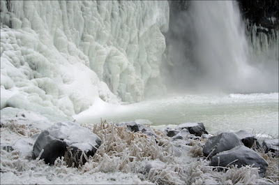


I made several visits to the park this winter to sack up and haul trash out of the canyon. Thanks to Rick and Cliff for helping on one of the trips. I've got some friends from the Ice Age Floods Institute lined up to help next year.


That's Cliff Burt near the top. Not that hard to get out of here but ... as you try to maneuver sacks through brush and a slot in the canyon wall - You sure think bad thoughts about the slobs that leave trash on the canyon floor.
On the climb out your clothes soak up most of the old beer leaking from the sacks.


A quick stop at the falls (29 Jan 12) - on our way to hear geologist/author Scott Burns talk about his book Cataclysms on the Columbia: The Great Missoula Floods at Spokane Community College.
On this day the Palouse River carried some soil. Pool below falls looked like chocolate milk.

Thanks to the Spokane Community College Science Department for hosting Dr. Burns as part of their Geology Lecture Series. The place was packed ... They were able to quickly set up a video feed to a large classroom across the hall for those that didn't get seated in the auditorium.
Proceeds from his book sales help fund scholarships in the Geology and English Departments at Portland State University.
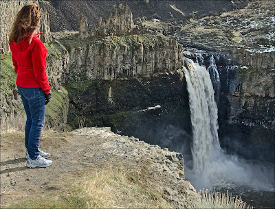
Teresa loves Palouse Falls - she attended sixth grade in nearby Kahlotus. The flow on this day was about 575 cubic feet per second. Two days later - warmer temps led to melting snow upstream and a 2,500 cubic feet per second flow.
I wish more people would visit that park. My favorite times are spring and early winter. My best advice for finding a bunch of ice is to watch for long periods of cold weather with NO warm days mixed in. The ice is usually slow to build and is quickly shed from canyon walls when temperatures warm. A Discover Pass is required to enter the park.
This image and the one below are the other two used by the Herald last year. Click to expand this shot. Try to imagaine canyon completely filled with Ice Age Floodwater. Once again ... I had the place to myself.

Palouse Falls is impressive at 5,000+ cubic feet per second - but that's just a tiny trickle compared to the Ice Age flows! On big flow days you'll probably find a few others at the viewpoint.
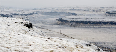
This ditch was way too small to handle Cheney-Palouse volumes as Glacial Lake Missoula drained! Like Palouse River Canyon and Devil's Canyon - HU Ranch Coulee was created when floodwaters overtopped the south rim of Washtucna Coulee and found huge fractures in the basalt. The floods cut deep channels in these locations between Washtucna Coulee and the Snake River.


SR-261 climbs out of HU Ranch Coulee near entrance to Palouse Falls State Park.

Here's another geocache "Trackable" Luke ended up with. This guy (Salt and Pepper) was found on a highpoint near Island Plateau in Grant County.

New Year's Eve hike to Bruce Bjornstad's Rattlesnake Slope Erratics geocache. Argillite boulders above Columbia River Basalt - pretty cool story.

Luke hides cache container (with Salt and Pepper inside) among argillite boulders.

Red line shows part of the route Luke and I took around Echo Basin. Frenchman Coulee is a great place to visit if you're interested in the Ice Age Floods. A Discover Pass is required to park in this area.

Looking down rib that separates Frenchman Coulee and Echo Basin. This shot was taken during the Ellensburg Chapter of the Ice Age Floods Institute fall field trip. That adventure was lead by chapter President Nick Zentner (CWU geologist).

Nick uses a small tub to illustrate Quincy Basin overflow. Water bottle discharge represents Ice Age Floodwater pouring from Grand Coulee into the Quincy Basin. The two small streams flowing from Nick's tub are Potholes Coulee and Frenchman Coulee. (When Nick gets really good at this he'll be able to also show flow through Drumheller Channels, Crater Coulee, Gorge Amphitheater and a small dribble between Potholes and Crater Coulees.) The point of this talk was the formation of Frenchman Coulee - Great job Nick!
I understand that Nick had 167 in attendance at the February 2012 Ellensburg IAFI meeting.
I hope I don't get you turned around here. The view in this shot is looking south into the Quincy Basin (Note location of Soap Lake). This is the mouth of the Grand Coulee. Huge volumes of floodwater shot out of this channel into the Quincy Basin. Large sediment (boulders) dropped out of the flow as the Grand Coulee floodwaters spread out into the basin.

While we're in this area ... Here's a better shot of Soap Lake. On windy days white foam accumulates on the shore.

A strange place - The Ephrata Fan. This shot looks north to the Grand Coulee.
South of Soap Lake (and southwest to Ephrata) are several miles of boulder-covered terrain (more boulders under the boulders you can see). The velocity of the flow in the Grand Coulee was strong enough to tumble this material in the bedload. As soon as the water had room to spread out - the depth and speed of the current was reducued and these things settled to the bottom of the temporary body of water that filled the Quincy Basin.
Don't miss this feature if you're new to the Ice Age Floods story. A couple friends that I've taken around to various features have told me that they didn't really "get it" until I showed them the Ephrata Fan at the mouth of the Lower Grand Coulee.
You can view a similar boulder field south of Sentinel Gap between the highway (SR-243) and Columbia River.

Teresa inspects a large erratic boulder south of Sentinel Gap. Note the surrounding basalt boulders. Just like the Ephrata Fan (picured above) boulders dropped out where the floodwaters spread out entering the Pasco Basin.

Flood debris below Sentinel Gap makes it tough to develop expansive lawns.
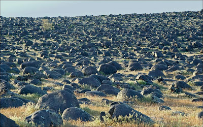 Drive south of Boise, Idaho to see yet another impressive boulder field downstream from a constriction. Boulders shown in this image are sitting below Swan Falls along the Snake River. These boulders were tumbled and piled by the Bonneville Flood.

As you travel south on the Ephrata Fan - you'll notice the floods have graded the material. The boulders get smaller and smaller. The farther south you go the smaller the stones. Some farmers have removed rocks from fields to allow farming. Another mile or two south and you'll start seeing healthy crops in good soil under pivot irrigation systems.

Many huge boulders moving with the Grand Coulee floodwaters did not settle out near Soap Lake - They were rafted south within icebergs. Some icebergs grounded and later melted - leaving clusters of erratics. This group of boulders were stranded on the northern slopes of the Frenchman Hills (south rim of Quincy Basin). When the Grand Coulee Project was built and irrigated farms were developed - Many erratics were blasted and moved to the edge of the fields or used as fill.
Photo shows: Brent Cunderla (blue/black coat at center) - BLM geologist and President of the Wenatchee Chapter of the Ice Age Floods Institute leading Ice Age Floods field trip during the Othello Sandhill Crane Festival.

Photo shows glacial debris on Mt. Rainier. Glaciers are often known as "Nature's conveyor belts". Vist Mt. Rainier in late fall to see boulders that have accumulated on and within glacial ice.

Huge out of place boulder near George, WA (Quincy Basin). Some of the lone boulders separated from icebergs and plunged to the bottom of the temporary body of water that filled the Quincy Basin. Isolated erratics distributed in this manner are known as Drop Stones. Either road builders or farmer have shoved this one around.

Notice the angular shape of this Frenchman Coulee Rib erratic. The lack of rounding tells us that this is pretty much where the iceberg left it (no bedload tumbling).
I carry this hammer for scale only (9' handle). I've never struck a rock with it.
Please leave erratics as you find them. Thanks!
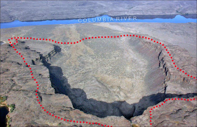
Sorry I got off track with the boulder deposits. Point was ... floodwaters filled Quincy Basin ... big stuff settled out early and the escaping water cut into the basalt carving scabland channels and magnificent coulees like Echo Basin pictured here. Hiking around rim you get some great views of columnar basalt and a gigantic plunge pool.

Columbia River flows south through Sentinel Gap in the distance. Note I-90 and Vantage Bridge (Vantage, WA far shore).

Luke reaches into "The Snake Den" geocache. In warmer months I'd suggest using caution when reaching under this and similar rocks in the area. Seems to be a healthy rattlesnake population near Frenchman Coulee and Babcock Bench.

Here's that owl again - This time in front of Sunshine Wall (north wall of Echo Basin). Luke found him in the container pulled from "Snake Den" geocache.
Follow the owl's adventure at:
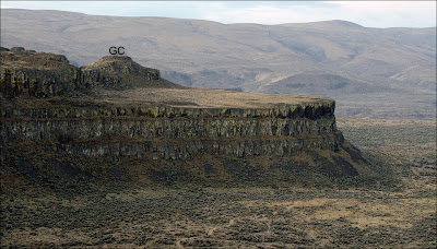
"GC" on highpoint above Island Plateau is where the little panda bear pictured above was found. The floods sure did an amazing job taking the basalt flows apart in this area.

Luke hops around on Roza flow column tops near Bruce Bjornstad's Frenchman Coulee Rib geocache.

Photo taken spring 2011 shows columnar basalt tops in Drumheller Channels.

Here's another shot from the top of a Drumheller Channels mesa/butte. This columnar basalt exposure looks like a cobblestone path.

Exposed basalt column tops between Frenchman and Potholes coulees.
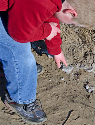
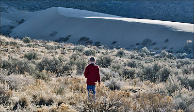


Photo taken from the west side of Columbia River (Fall 2011 hike). You can see our track over the dune at lower right.Lake Missoula floods easily removed basalt columns. Another view of point marked "GC" above Island Plateau.

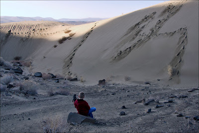
Stopped to empty shoes before short hike up to Island Plateau.

Luke stands on solid Columbia River Basalt Group footholds while his spotter steps away to snap a quick photo.


A couple huge ice-rafted erratics (shown in the next two photos) sit on hillside beyond "Columbia River" notation.


View from this erratic includes Columbia River - arrow points to the highpoint you know as "GC".
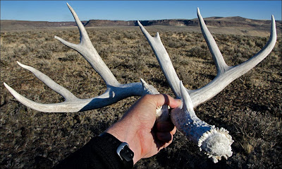
Lots of deer and elk on Kittitas County side. Frenchman Coulee behind antlers. I now leave these things where I find them. When you start hiking in the scabland you end up with a pile of them.

One more Frenchman Coulee view from the other side of Columbia River. Tom/Luke route off rib between Frenchman Coulee and Echo Basin shown in red.

We're back on the Grant County side now - Road for scale on the giant flood bar at Echo Basin mouth.
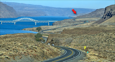
If you're not sure where we're at - This image shows the same bar and road beyond Vantage Bridge - arrow.


If you're interested in the Ice Age Floods and have not visited Frenchman Coulee - Please take this I-90 exit and drive down to the river (dead end) It only takes a few minutes. If you drive down and are not impressed - I'll give you a beer (Offer limited to the two beers I found in Palouse River Canyon).

What a treasure! The petroglyphs on this thing are incredible. This was my second visit to this rock (I'm not counthing the times I walked by it without noticing the special markings). The depth of the scratching is impressive.

Visit the Columbia Gorge to view She Who Watches.
Trip Report from this area: The Dalles and "She Who Watches"

Many petroglyphs were moved to higher ground when Columbia River dams were built.
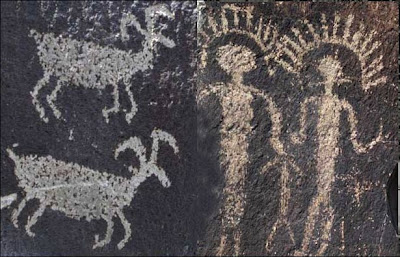
Petroglyphs shown in this photo are on display at the Ginkgo State Park visitor center.

Dozens of basalt boulders rounded by the Bonneville Floods near Celebration Park (Snake River canyon south of Boise, ID.) are marked with petroglyphs.
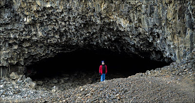
Lake Lenore Caves were carved by floodwaters from Glacial Lake Missoula. Early coulee residents used the many caves in this area for shelter and storage.
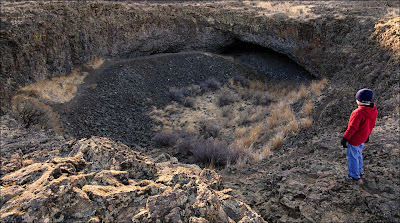
Numerous potholes in the area. These things were drilled into the basalt by tornado-like currents in the floodwater.
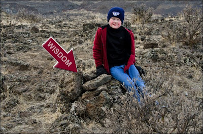
This is where we parted ways with "Wisdom". He's in this pile of rocks at:

Luke locates the Lk Lost N Time geocache. We're in the huge channel east of Lake Lenore.


The frozen surface of Blue Lake was like glass. I think we both may have set 'personal best' rock throwing distance records.

Luke checks out displays at the Dry Falls State Park visitor center. Those are some impressive teeth!

Luke likes science and seems interested in geology. Teresa, Luke and I visited the Smithsonian in November. Lots of 'Smiling Luke' photos from that trip but - he struck a serious pose in front of the gold display ... and did the same when standing next to Eddie Van Halen's guitar.

Luke's favorite activity is riding dirt bikes with his Dad. I'm glad he doesn't mind a few slow-paced scabland hikes with his uncle.
Click below to watch Nick Zentner interview USGS Geologist Richard Waitt.
New and Interesting!!!
If you have a few minutes - check out the new Columbia Gorge IAFI Chapter website. Chapter founder and president Terry Hurd is a good guy and works hard to help others understand and enjoy the Ice Age Floods story.


