UPDATE: I added a second Wallula Gap post to this blog after a November hike on the west side of the Columbia River. Click to open: Wallula Gap (West).
Hey!!! Check it out ... I'm not the last guy on the planet to start a blog! It seems like I'm always reading blogs and wanted to see how they're created and maintained so I just fired up this Ice Age Floods blog on Google's free Blogger program.
When I opened the "Edit Post" box I noticed an icon to add an image - I clicked it and selected the shot above of an ice-rafted "erratic" grounded high in the Horse Heaven Hills near Wallula Gap (15 miles from our house). So this is where the blog starts ... Wallula Gap.
A quick note about the images - I guess an easy way to date them would be to tell you that the ones with green grass were shot in the spring of 2006 - and the images with dead/brown grass were taken this week.

Wallula Gap
For millions of years the Clearwater-Salmon, Snake and Columbia Rivers have maintained this breach during the uplift of the Horse Heaven Hills. This choke point is located 15 miles south of Pasco, WA. Wallula Gap is the only outlet for stream flows from the entire Columbia River Basin of eastern Washington.
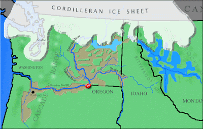
When the Ice Age Floodwaters converged in the Pasco Basin, Wallula Gap restricted the outflow creating massive Lake Lewis. In their book Cataclysms on the Columbia, John Eliot Allen and Marjorie Burns reference a calculation of water flow through Wallula Gap at 1.66 cubic miles per hour or nearly 40 cubic miles per day for at least 10 days (Weis & Newman, 1973).
The normal river surface elevation is 335-340 ft. On each side of the Gap, Ice Age Flood overflow channels are found up to 1,250 feet - many ice-rafted erratics are found just below just below that maximum elevation! As the water filled the Pasco Basin it lost the velocity required to transport some of the gravel and silt that had been stripped from areas to the north. Much of this material was dropped in the Pasco Basin.

Two Sisters at Wallula GapDuring the largest Ice Age Flood events, these basalt pillars were under 600 feet of water!The large basalt pillars are actually two Cayuse Indian sisters. Coyote, a spiritual hero of many Indian legends, fell in love with three sisters who were building a trap in the river to catch salmon. Always the trickster, Coyote watched them and at night would destroy their work. The sisters rebuilt the trap daily but Coyote would destroy it each time. One morning Coyote saw the sisters crying. They were starving for fish. Coyote promised them a trap if they would become his wives. The sisters consented and he kept his promise. For many years Coyote lived happily with the sisters but after a while he became jealous of them. Using his supernatural powers, Coyote changed two of his wives into basalt pillars. The third wife he turned into a cave downstream. He then turned into a rock so that he could watch over them forever.-From WSDOT sign at Wallula Gap. |
Check Out These Links:
- A nice site by Lyn Topinka: Wallula Gap History
- Good stuff by geologist Bruce Bjornstad: Wallula Gap Geocache
OK ... This one's a little tricky. I'm trying to follow everyone's rules so I'm not linking directly to an image at the University of Washington. To open a great image: Click link below to open the UW Libraries Digital Collection. When the page opens - type "Wallula Gap" into the "Quick Search across all collections" box at the center of the page and click "Search". Once the image page opens, click to expand full screen: Wallula Gap and Sternwheeler
Ice Age Floodwaters from Lake Missoula
|
and Lake Bonneville flowed through Wallula Gap
The Corps of Discovery described the exposed basalt at Wallula Gap as "black rugid rocks ..."


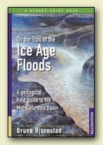
Bruce Bjornstad's book - "On the Trail of the Ice Age Floods" is an excellent source of information on Wallula Gap and many other incredible Ice Age Floods features. The formation of Wallula Gap is described along with hikes and tours in the area. Illustrations include maps and photos of the Wallula Gap area. Stev Ominski artwork on cover.

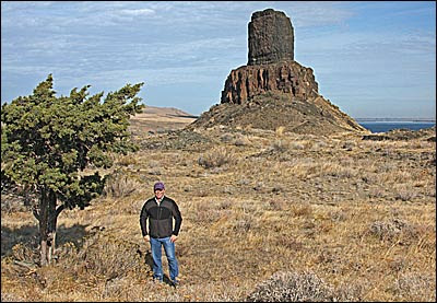
Wallula Gap Timber: That's me standing next to one of the few trees at Wallula Gap. The arid climate and lack of vegetation allows us to view the awesome landscape created by the Ice Age Floods.
[Photo by Orin]
All images by Tom Foster unless noted. Students/Teachers working on an Ice Age Floods project - Let me know if I can help you with images.
Update September 2014: Hanford Reach Interpretive Center is now open with exhibits covering the Columbia River Basalt Group, Ringold Formation and the Ice Age Floods.
Discover the Ice Age Floods at: http://hugefloods.com/
Discover the Ice Age Floods at: http://hugefloods.com/


No comments:
Post a Comment